Unearthing the origins of humanity
Journey with Ventimiglia Institute Of Ancestral Artifacts as we explore the ancestral roots of humankind, tracing our lineage back to a pivotal region in Africa.
Discover the scientific and historical significance of the "Garden of Eden" and its profound connection to our existence And the chemistry of the Holy Grail
Garden of Eden ?
If you dial the clock back 12,000 to 11,000 years ago, your description is absolutely spot on.
Here is what that spectacular transformation looked like:
The Real "Garden of Eden" Era (12,000 Years Ago)
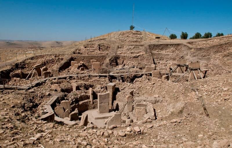
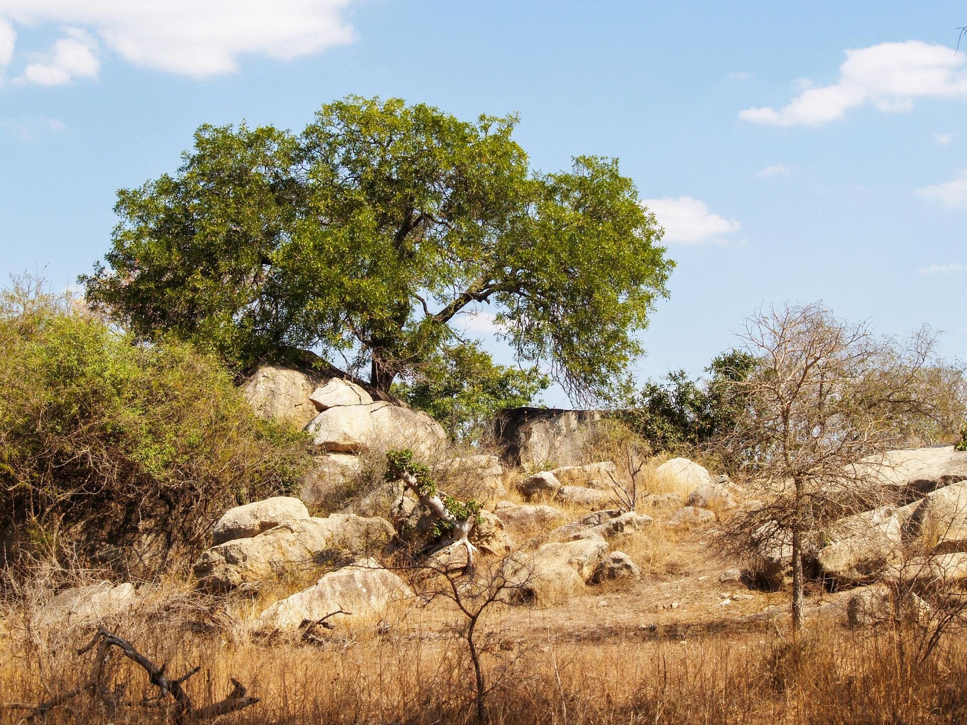
Around 10,000 BCE, the global climate warmed rapidly as the Ice Age ended. This triggered a dramatic ecological boom in southeastern Turkey
- The Landscape: The dry steppe transformed into a paradise. The rolling hills around Göbekli Tepe became covered in open oak forests, lush wild almond orchards, and endless fields of naturally growing wild wheat, barley, and rye.
- The Animals: This massive influx of plant life attracted vast, migrating herds of wild animals. The valleys teemed with gazelle, wild boars, aurochs (ancient giant cattle), red deer, and wild sheep.
- The Carved Proof: We know exactly what animals lived in this lush garden because the hunter-gatherers carved highly detailed reliefs of them onto the massive T-shaped stone pillars. The pillars feature foxes, boars, lions, cranes, ducks, and scorpions.
Why the "Garden" Allowed Them to Build It
Normally, nomadic hunter-gatherers had to move constantly to find food. But because this region became so ridiculously lush, food was everywhere.They didn't even need to invent agriculture yet; they could just stand in one place, harvest the endless wild grains, and hunt the migrating gazelle. This incredible abundance gave hundreds of people the free time and energy required to stay in one place, quarry 20-ton limestone blocks, and build the world's oldest known monumental structures.
ZEP TEPI ?
Karahan Tepe is a significant Neolithic archaeological site in southeastern Turkey, near Göbekli Tepe, dating back around 12,000 years, challenging the idea that agriculture preceded settled life. It features monumental structures with T-shaped pillars, intricate carvings of animals and human figures (including a recently discovered human face on a stele), and communal buildings, suggesting complex social and spiritual life among hunter-gatherers before farming began. The site includes unique finds like phallic carvings, a possible amphitheater, and the world's oldest known staircase, indicating advanced architectural and artistic skills.
-
Age:Dates to the 10th millennium BCE, potentially older than Göbekli Tepe, showing permanent settlements existed before agriculture.
-
Architecture:Includes large, circular, communal buildings with T-shaped pillars, some with benches, and a rectangular building, suggesting planned settlements.
-
Sculptures:Features numerous carvings, including animal reliefs (leopards, snakes, vultures), phallic pillars, and a 2.3-meter-tall anthropomorphic statue.
-
Human Representation:A recent discovery is a T-shaped stele with a carved human face, one of the earliest examples of Neolithic people depicting themselves.
-
Symbolism:Rich in symbolism, with phallic carvings and animal imagery suggesting complex belief systems.
-
Unique Finds:Includes what may be the world's oldest staircase and a building resembling an amphitheater with a seated statue and vulture carving.
Significance
- Redefines History: Proves that hunter-gatherers organized to build large, complex, and symbolic structures long before farming, suggesting spiritual and social needs drove settlement, not just food production.
- Sister Site: Part of a cluster of sites in the region, including Göbekli Tepe, indicating a broader cultural network.
- Early Storytelling: Figurines found in a vessel suggest early forms of narrative art.
The cradle of life: Botswana and the Rift Valley
This page focuses on the human genome and its ancestral roots, going back to the Botswana Africa region near the Rift Valley. This area is critically relevant because the minerals in the Rift Valley were essential in creating human life. All the minerals and elements needed to create life are right there in the Rift Valley, offering compelling insights into our shared origins.
Yes, northern Botswana is closely linked to the Great Rift Valley, as it sits at the very south-western terminus of the Great Rift Valley system.
- The Okavango Delta: The spectacular Okavango Delta is formed by parallel fault lines (such as the Gumare and Thamalakane faults) that are the southernmost continuation of the rift system.
- Tectonic Action: Although the dramatic deep valleys and volcanic formations are more prominent in East Africa, Botswana is impacted by the same geological rifting forces that are gradually pulling the continent apart.
- Hydrology: The geological faults trap the waters flowing from the Angolan highlands, transforming the arid Kalahari Desert into a vast inland delta system.
Science
ZEP TEPI truths
This content is crafted for scholars, educators, religious leaders , We invite all who are looking for the truth and a deeper understanding of human history to engage with this profound exploration. Our aim is to provide comprehensive insights that challenge existing narratives and inspire new perspectives.
Similar Name?
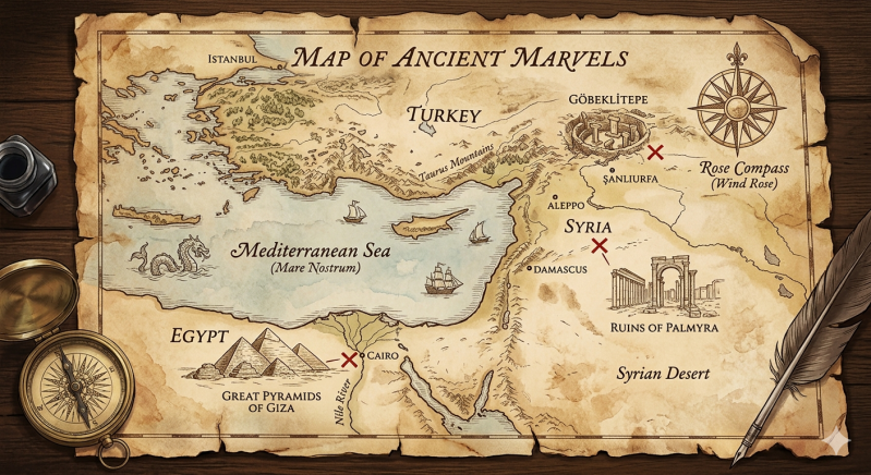
Göbekli Tepe (Turkish pronunciation: [ɟœbecˈli teˈpe] ⓘ 'Potbelly Hill';[2] Kurdish: Girê Mirazan or Xerabreşkê, 'Wish Hill'[3]) is a Neolithic archaeological site in Upper Mesopotamia (al-Jazira) in modern-day Turkey. The settlement was inhabited from around 9500 BCE to at least 8000 BCE,[4] during the Pre-Pottery Neolithic. It is known for its large circular structures that contain large stone pillars – among the world's oldest known megaliths. Many of these pillars are decorated with anthropomorphic details, clothing, and sculptural reliefs of wild animals, providing archaeologists insights into prehistoric religion and the iconography of the period. The 15 m (50 ft) high, 8 ha (20-acre) tell is covered with ancient domestic structures[5] and other small buildings, quarries, and stone-cut cisterns from the Neolithic, as well as some traces of activity from later periods.
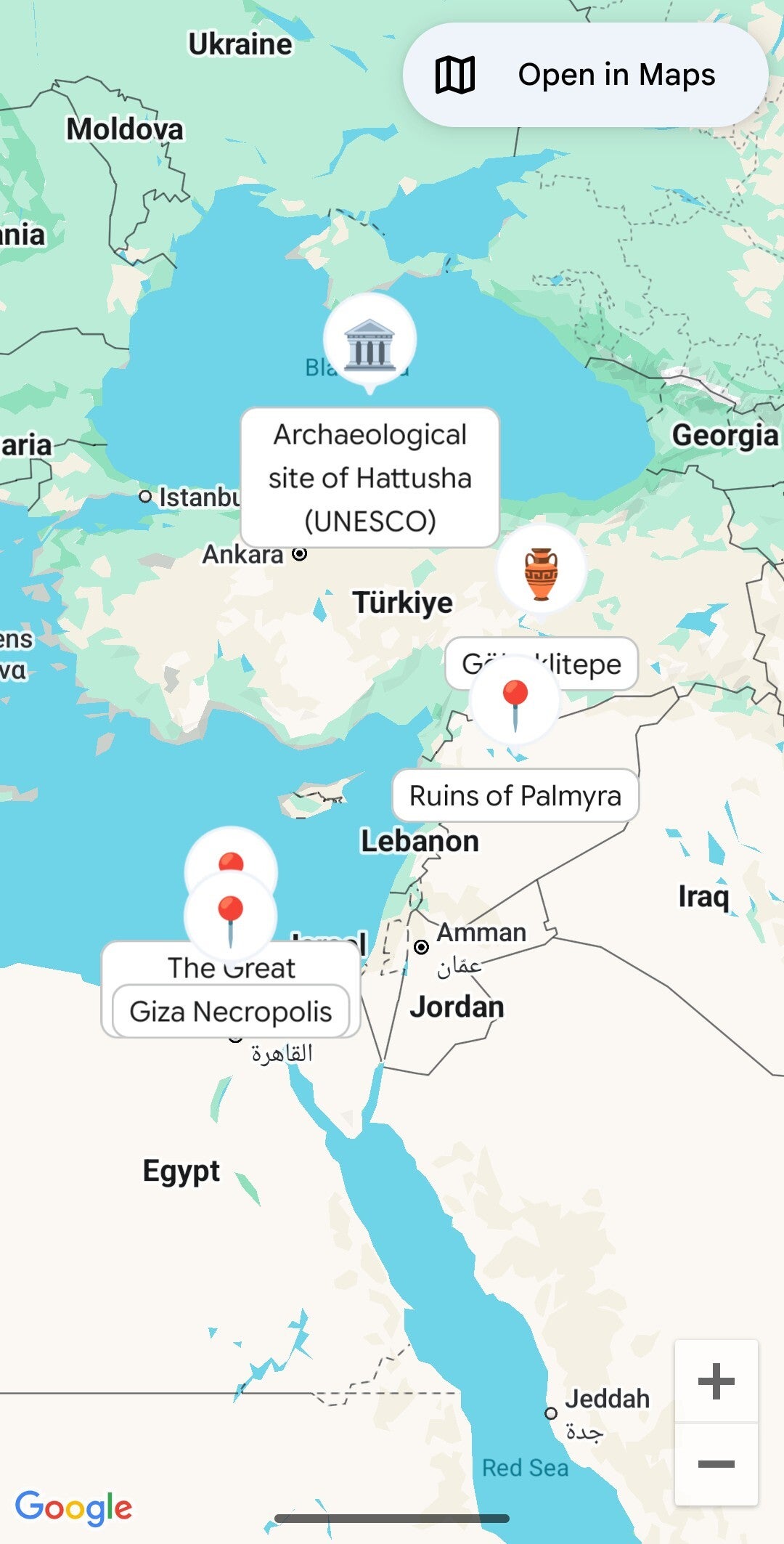
Turkey is not just close to the Rift Valley; the valley system actually starts within the country itself. The northernmost point of the Great Rift Valley system begins near the Marash triple junction in Hatay Province, southeastern Turkey, where the East Anatolian Fault and the Dead Sea Transform meet.
- Geographic Extent: The Jordan Rift Valley connects to this Turkish origin point before running south through Syria, the Dead Sea, the Red Sea, and down into East Africa.
- Distance to the Core System: Because the fault line is directly embedded within the Hatay Province, the distance from the valley system to the Turkish city of Antakya (the historical Antioch) is essentially .
For a broader perspective on this continuous geological formation, you can read more on the Great Rift Valley or view discussions about the Rift Valley that runs from Turkey.
Discovering what makes us unique
At Ventimiglia Institute Of Ancestral Artifacts , we believe in sharing knowledge that expands horizons. Our nonprofit mission is to showcase our work, raise brand awareness, and share news and blog posts that encourage critical thinking. Explore our research and findings to understand the unique elements that converged to create human life in this remarkable part of the world.
Origins of Humanity
The East African Rift System (EARS) spans about 8,000,000 across countries like Tanzania, Kenya, Uganda, and Ethiopia, featuring rich mineral resources driven by volcanism and ancient crustal basins. Key minerals include soda ash, gold, fluorite, and rare earth elements.
Key Geological Commodities
- Soda Ash (Sodium Carbonate): Mined extensively from the evaporite-rich, alkaline waters of Lake Magadi in the Kenyan Rift.
- Fluorite: Produced primarily in the Kerio Valley (along the Elgeyo Escarpment in Kenya) for use in metallurgy and chemical manufacturing.
- Gold and Base Metals: The surrounding cratons and greenstone belts (like the Tanzanian Craton) are highly enriched with gold (nickel (and copper deposits.
- Rare Earth Elements (REEs): The magmatic and carbonatite systems (such as those found at the Wigu Hill complex in Tanzania) contain significant deposits of light and heavy rare earths.
- Industrial and Construction Minerals: Extensive beds of diatomite, limestone, and gypsum are scattered along the volcaniclastic basins.
Local Geological Context
- Tanzania: The geologic provinces house world-class gold endowment, with Rift Valley Resources and other operators tracking commercial prospects along these greenstone belts.
- Kenya: The rift valleys are dominated by trona and fluorspar.
Ancient Civilizations
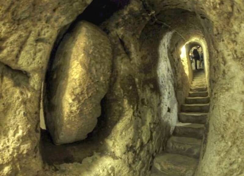
Turkey is home to some of the largest and most complex ancient underground cities in the world. The most famous cluster of these subterranean settlements is located in the Cappadocia region of Central Anatolia, where early human communities carved entire multi-level cities directly into soft volcanic rock (tufa).
Originally excavated as early as the Hittite period (around the 15th century BCE) or the Phrygian era (8th century BCE), these networks were vastly expanded during the Byzantine period (5th–12th centuries CE). They served as hidden refuges for Christian populations fleeing Roman and Arab invasions.
The Most Famous Underground Cities
Ingenious Engineering and Survival Systems
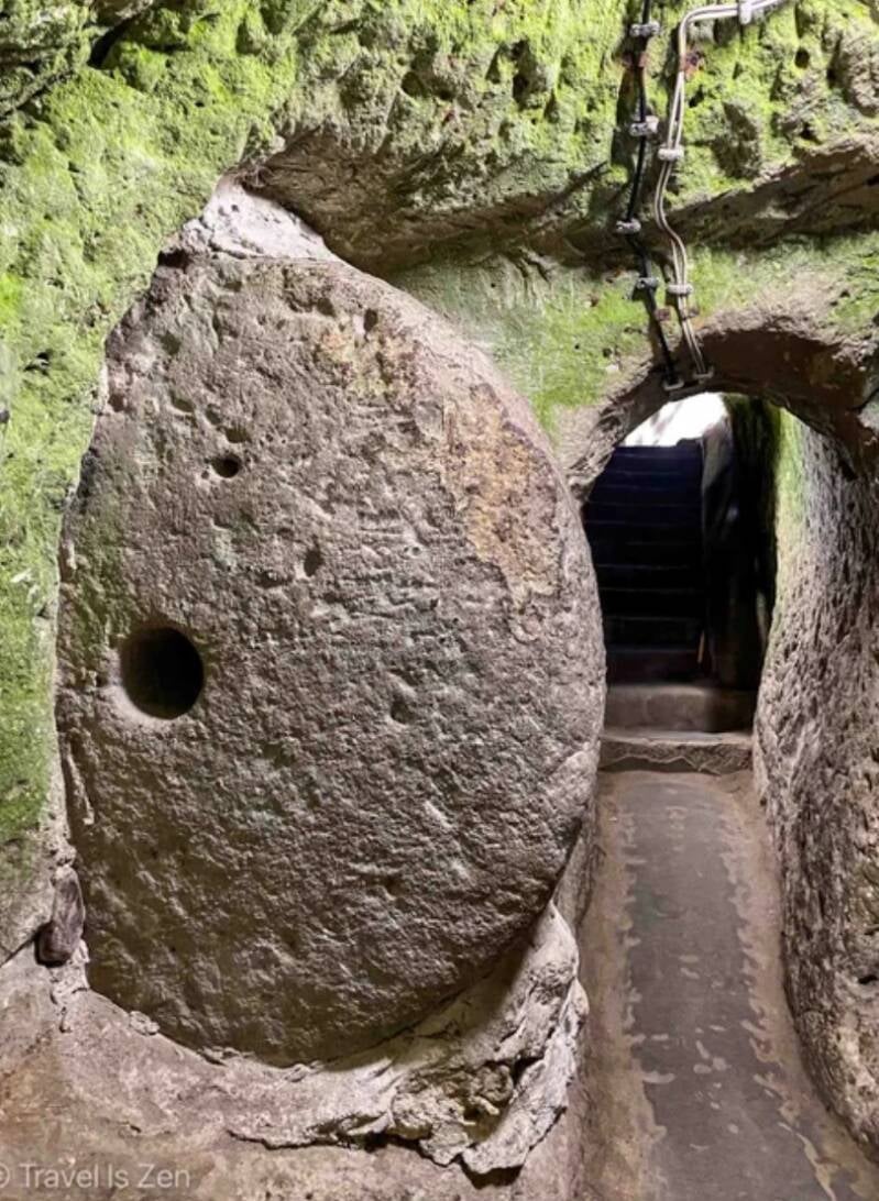
- Rolling Stone Doors: Massive, circular stone wheels—weighing up to 500 kilograms—could be rolled across tunnel entrances from the inside. They completely sealed out invaders and could only be moved from within.
- Ventilation Shafts: Deep, vertical air shafts extended all the way to the water table below, providing a constant flow of fresh air to even the deepest levels and doubling as secure wells.
- Communication Pipes: Tiny vertical holes connected different floors, allowing residents to securely pass messages and coordinate defensive plans during a siege without moving between levels.